There are a number of other providers of near-real time tree cover loss detection systems. But most of these systems do not differentiate tree cover loss from deforestation, which makes a world of difference if you want accurate alerts to take appropriate action. Satelligence does make this distinction. That is why our deforestation detection system results in actionable insights, instead of general information on blanket deforestation.
To compare differences in the detection systems, we used Ghana as a case study because it is a notoriously difficult area to detect deforestation. There is almost persistent cloud cover throughout the year, a lot of atmospheric haze, and the deforested areas are relatively small compared to the large-scale deforestation seen in Southeast Asia and Central and South America.
In Ghana, the Satelligence deforestation detection system has an accuracy of 83%, which is, considering the difficulties of the area, a very good result. In other areas, we achieve an accuracy of at least 95%.
We also assessed the accuracy of the GLAD system that is available through Global Forest Watch. This near-real time system uses the (optical) Landsat satellite constellation, and was developed for Indonesia, Malaysia, Peru and the Democratic Republic of Congo. Unfortunately, we cannot provide a comparison with other (commercial) systems here, because the data they provide are not open-source.
Using the same reference dataset, we found that the accuracy of the GLAD system in Ghana was 45%. Notably much lower than Satelligence. The higher accuracy rate of our system is due to the incorporation of radar data, which makes it possible to look through cloud cover.
The image below demonstrates the significant difference between Satelligence and GLAD systems. Whereas we pick up all the changes that occur within the area, GLAD only picks up a few pixels, which account for only a fraction of the area actually cleared. Please note GLAD is the early detection system of Global Forest Watch which is a different product than the yearly Tree Cover Loss.
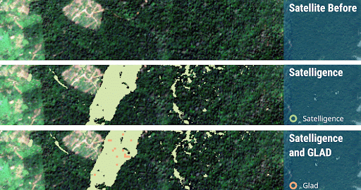
Before and after satellite images of an area in Ghana (top), near-real time deforestation detected by Satelligence in green (middle), near-real time deforestation detection by Satelligence in green and GLAD overlaid in orange (bottom). Note the large difference between the amount of deforestation detected between Satelligence and GLAD during the same time period.
Deforestation detection timeliness
Deforestation is happening continuously. So when it happens, you want action to be taken as quickly as possible. It is therefore also important to check how much time it takes for our system to detect an alert after it actually happened, and how this compares to other systems. Our reference dataset uses the earliest deforestation date that can be established. We then cross-reference the deforestation alert derived from our detection system, to see how much time it takes before a deforestation event is actually detected. The same is done for results from other providers available in Brazil, to compare timeliness between systems.
In the example below, we use an area in Brazil to test the spatial accuracy and the mean difference between the dates in the reference dataset, and provide a comparison of the deforestation detection services of Satelligence, GLAD and PRODES.
In the images you can see that both Satelligence and PRODES detect a lot more deforestation than GLAD. This is also reflected in the accuracy figures in the table below, where Satelligence reaches an accuracy of 99.4%, while PRODES and GLAD only achieve 66.9% and 68.5%, respectively.
If we look at timeliness, there are large differences in the detection of the deforestation pixels. Satelligence has an average lag of 24.3 days, while GLAD is up to 87 days and even up to 286 days for PRODES. This is due to PRODES being a system where deforestation is labeled manually. One such large delay occurs for the deforestation patch in the west of the image below. Reference data indicates this area was deforested on October 10, 2018. Satelligence and GLAD record the deforestation on October 18, while PRODES only records it on July 18 2019, 8 months after the actual event.
|
ystem |
Spatial Accuracy (%) |
Temporal Lag (days) |
|
Satelligence |
99.4 |
24.3 |
|
GLAD |
68.5 |
87.0 |
|
PRODES |
66.9 |
286 |
Table: Deforestation detection accuracy and temporal lag of Satelligence, GLAD and PRODES systems for an area in Brazil.
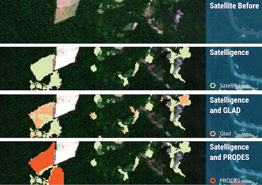
Before and after satellite images of an area in Brazil (1st), near-real time deforestation detected by Satelligence in green (2nd), by Satelligence in green and GLAD in orange (3rd) and by Satelligence in green and PRODES in red (4th). Note the large patches of deforestation that both GLAD and PRODES are missing.
Although it seems as though the Satelligence system still takes quite some time in detecting deforestation (24.3 days), this lag is in reality much smaller. This is because our reference dataset is also based on optical satellites. So when there is extensive cloud cover it is hard to determine the actual deforestation date. This means that the date we have put into our reference dataset can be up to a few weeks early, making it seem like the detection has a long lag.
The above analysis shows that the Satelligence deforestation monitoring system is more spatially accurate, more timely and more context aware (tree cover vs forest cover) than the GLAD system.