To comply with the European Deforestation Regulation (EUDR) you need to make sure the products you place on the European market are deforestation free. The Regulation sets out the due diligence that needs to be carried out in 38 articles but the essence can be summed up in 3 steps after which Operators can submit Due Diligence Statements to the EU Information System:
- Collect plots, the geolocation coordinates of land where the relevant commodities that the relevant product contains, or has been made using, were produced. Palm, cocoa and coffee are examples of these commodities, see ANNEX I for the complete list commodities and products that fall under EUDR.
- Make sure the commodity and products are deforestation free and produced in accordance with relevant local legislation before placing them on the European market.
- Carry out a risk assessment to establish whether there is a risk that the relevant products are noncompliant and mitigate any non-negligible risks
The best way to have compliant shipments is to continuously work on supply chain visibility, risk assessment and risk mitigation. Proactively mapping your suppliers and the plots, assessing the risks and monitoring deforestation in your sourcing landscape. This way you ensure you always have compliant supply. If you have to start from scratch, start with collecting plots.
To become compliant you need to familiarize yourself with the regulation. We read it from here
How to collect plots with the Supply Chain Manager
With the Supply Chain Manager tool you manage all your supply information on the platform. This is how to use it for EUDR compliance.
Ready?
You have agreed on a monitoring region (a list of countries or more granular) and have access to the best deforestation data through app.satelligence.com. You can verify this by checking the map at app.satelligence.com/map and look for highlighted areas. The example below shows a palm company with access to Riau in Indonesia.
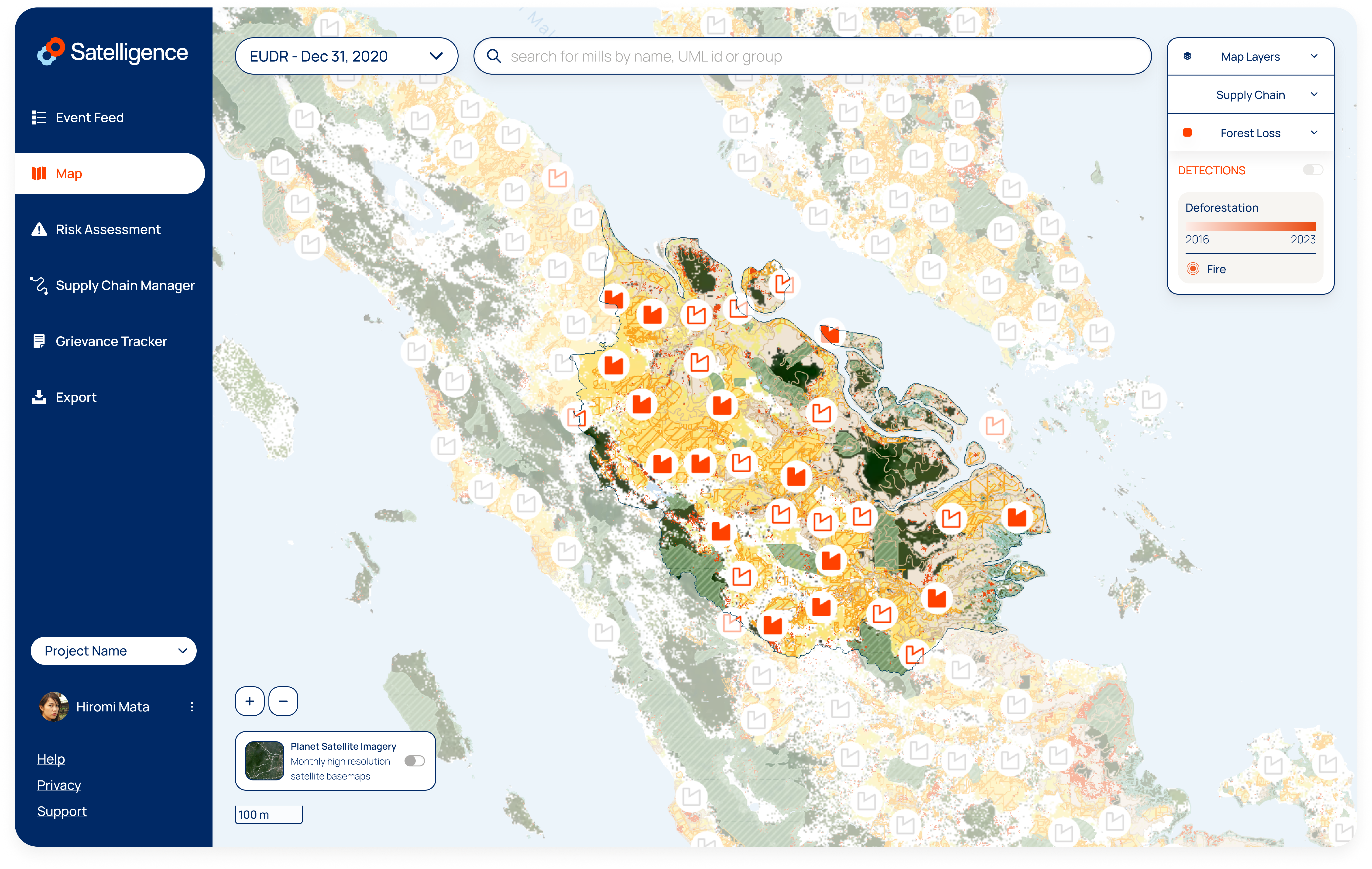
You can collect plots in regions outside of the highlighted area, but the risks assessments are confined to the highlighted region. Contact your customer success or account manager to modify the monitoring area if needed.
If you do not have access to the platform, check our FAQ or contact support@satelligence.com
Set
Satelligence provides risk assessments and real time monitoring of the plots of your suppliers. In most value chains the plot data collection is delegated to suppliers but at some point someone has to measure the "geolocation coordinates of land where the relevant commodities that the relevant product contains, or has been made using, were produced". If you do not have the plots, reach out to your suppliers or send out your field teams to gather the data. If you do not know where to start contact your customer success or account manager for help. Reach out to us when the data collection with your suppliers is going to be a very signification effort, our Jurisdictional Risk Assessment can help you scope that effort. We have an extensive network of suppliers, many of which are clients on the platform. Through that network we can accommodate fast and efficient data sharing.
Start
Navigate to the Supply Chain Manager tool using the left menu or go to app.satelligence.com/supply-chain-manager. The Supply Chain Manager allows you to add suppliers and start uploading plots for them or send a list to support@satelligence.com. If you already have a Satelligence account then your supplier column will be pre-populated.
Read about all the Supply Chain Manager features and requirements in the Tools pages
Prepare Files: Plots need to be provided in GeoJSON format and represent Points, Polygons or MultiPolygons.
Upload Files: Select files from your file browser and drag those into the drop zone or click Browse to open a file picker. You can add multiple files and the files can contain a mix of different geometry types.
Error while uploading? You get a list of errors that you can fix yourself. If you need help then you can contact support@satelligence.com preferably including the plots you are trying to upload.
Successful upload? Navigate to the Risk Assessment page using the left menu and click on the supplier you just created to view its plots with their assessments.
Done
Now rinse and repeat this process until all your suppliers and their plots are in the system. After your initial upload, you can decide to add more plots for the same supplier, replace all plots or remove all plots by removing the supplier.
Apply Risk Assessment
It might not be all the plots in your supply chain, but you got started collecting plots in the Supply Chain Manager. The hardest part might be behind you but you are not ready yet to start shipping and submit data to the EC Information System yet. You first need to make sure the commodity and products are:
-
Deforestation free and produced in accordance with relevant local legislation
-
Carry out a risk assessment to establish whether there is a risk that the relevant products are noncompliant
-
Mitigate any non-negligible risks.
It's a lot, but made easy using the Risk Assessment tool. Navigate to the Risk Assessment using the left menu or go to https://app.satelligence.com/risk-assessment.
Overview
You will be presented with two main vertical columns. On the left the suppliers you added in the Supply Chain Manager and on the right the plots you uploaded for all your suppliers. The plots are categorized into Non-Deforestation Free, Deforestation Free and No Satellite Monitoring. The categories expand on click to list all the plots.
Click on the supplier to filter the plots for that supplier.
On the top you find a selector. This enables you to apply the same Risk Assessment for your EUDR compliance to cutoff dates for other frameworks such as the Cocoa and Forest Initiative (CFI) or No Deforestation no Peat no Exploitation (NDPE). For EUDR, make sure it says EUDR - Dec 31, 2020.
Risk Categorization
The Non-Deforestation Free category corresponds to noncompliant with EUDR Article 3a. Plots in this category contain deforested areas since the EUDR cutoff date and therefore the products from these plots cannot be placed on the European market.
The Deforestation Free category contains the plots that do not contain deforestation since EUDR for Article 3a but they might have other non-negligible risks inside the plot or in the immediate surrounding which we approximate with a 500 meter buffer. The regulation states that "operators shall carry out a risk assessment to establish whether there is a risk that the relevant products intended to be placed on the market or exported are non-compliant". We consider 4 risk factors:
-
Presence of forest: whether the plot contains forest or there is forest within 500m of the plot boundary
-
Presence of protected areas: whether the plot is inside a protected area or there are protected areas located within 500m of the plot boundary
-
Presence of indigenous territories: whether the plot is located inside community land or in an area designated as indigenous territory or those areas are within 500m of the plot boundary
-
Prevalence of deforestation: whether there is detected deforestation since EUDR cutoff date within 500m of the plot boundary
Mitigate non negligible risk
All the non-negligible risks for plots that are Deforestation Free need to be mitigated. In our experience the mitigation methods in the industry are not well defined yet but logically we see 3 main directions:
-
For any plot with non-negligible risk additional scrutiny on the correctness of the plot boundary is warranted. Work with your supplier to gather documentation of the plot boundaries (permits, licenses) and perform cross checks on aggregation points in the supply chain on whether the volumes may reasonably come from the provided plots.
-
For plots inside or within 500m of protected areas or indigenous territories there are legality risks. The plot might be located in an illegal area or the production is not in "consultation and cooperation in good faith with indigenous peoples" (EUDR Art. 10 crit. d). Request additional documentation and evidence from your supplier
-
For plots with the presence of forest or prevalence of deforestation risk factor you have our real time forest monitoring tools. With these tools you have visibility on the forest and changes to the forest in real time. As long as you follow up with your supplier on deforestation events you are good to go.
Follow up with your supplier on deforestation events
We do this using the event feed available at app.satelligence.com/feed, but before engaging with your suppliers on every potential noncompliance, first use the event feed filters to filter out events that you are not committed to mitigate or to lower the workload to a manageable amount.
We capture all deforestation from 1 ha in events with 0.1 ha increments. In landscapes with many smallholders in close proximity there will be less deforestation events than there are plots with prevalence of deforestation (our experience with cocoa and coffee). In other landscapes dominated by large plantations (palm) it can be easier to contact suppliers for each individual plot with prevalence of deforestation.
Filter out events
- Navigate to the Event Feed tool using the left menu or go to app.satelligence.com/feed
- Click on “filter options” and start with
- Your supply chain: Inside Plot and Close to Plot. This filters events to those that are overlapping with the plots you uploaded in the Supply Chain Manager or those within 500 meters.
- Set the type to deforestation. The platform also cover fires which are relevant for other frameworks but can be ignored under EUDR
- Any events in this filtered list with a last updated date after the harvest dates of your shipments should be your priority to resolve. Any other event since the EUDR cut off date of December 31 2021 should be resolved as well for your entire supply chain to be considered EUDR deforestation free.
- Optionally open the filter options and store these filter settings as your default filters to make sure you always focus on the same category events.
Engage with suppliers on potential deforestation risks
-
Click on any event of your filtered list to investigate it. You’ll see the event on the map and the timeline of all the detections. Visually review the deforestation data and plot boundary. We guarantee 95% accuracy of our data and in general plot data quality varies wildly. In most cases you have to take into account the accuracy of modern day GPS receivers of 3 to 5 meters.
-
Next to “timeline”, click on “supply chain links” to find all the potential links to this event.
-
If your supplier also monitors the same region with us they will be able to access the same event. Click on Copy URL and include this link in your communication with your suppliers. For offline use with any stakeholder, download a shapefile of the deforested area by clicking on the
 button. To include a satellite image in the engagement with your supplier you will need to take a screenshot. Turn on satellite imagery for the accompanying months from the button in the bottom left of the map and take a screenshot using the mechanism of your operating system.
 -
Engage with the relevant suppliers to request documentation and evidence that your supply is compliant outside of the platform. If the information cannot be provided, request them to exclude products originating from this plot. When you have confirmation you can replace the suppliers' plots in the Supply Chain Manager.
-
Note down the event id or the event URL that you copied using the Copy URL button and keep track of the actions you take with your supplier.
-
Close this event by clicking on the cross at the top right corner. You will be brought back to the filtered event feed, the event you just investigated will show in a toned down grey. Whenever the deforestation continues the event will resurface to the top of the feed and show as unread again.
Doing 1 to 6 consistently, ensures you mitigate all the significant deforestation risks in your supply chain. Whenever you get audited or receive accusations you will find events that you all followed up on (if any at all). You are now ready to receive shipments from your suppliers and submit Due Diligence Statements and plots to the EU Information System.
How to Submit Due Diligence Statements to The Deforestation Due Diligence Registry
When you have created a supplier, you uploaded the plots for that supplier, the plots are deforestation free and have non-negligible risk or you have mitigated all the risks: you are ready to extract data and submit this to The Deforestation Due Diligence Registry. In the Registry you can provide coordinates in bulk in GeoJSON. You can extract this file from the Risk Assessment tool in the platform:
-
Navigate to the Risk Assessment using the left menu or go to https://app.satelligence.com/risk-assessment
-
Click on the supplier you want to extract plots for in the left column
-
Double check whether all the plots from this supplier are Deforestation Free
-
Click on the download icon
 to download all the plots in a format ready for upload
 -
Head over to the documentation provided by the European Commission for details on how to do this. Submit the downloaded plots where it says upload in bulk
The Deforestation Due Diligence Registry is still in the pilot phase and under heavy development. Expect things to change