
Detecting deforestation consists of two basic components: knowing where the forest is located, and knowing if and when it changed to a non-forest state, i.e. deforestation.
We locate forest areas using our own Harmonized Nature and Commodity Baseline, and for knowing when forest changes into another state we use change detection algorithms. This system is faster and more precise than popular public alternatives without the need for expensive commercial input data.
Nature and Commodity BaselineSatelligence uses a hybrid approach for forest baseline creation. Meaning that we use both open data such as the Tropical Moist Forest Layers from JRC, as well as our own proprietary data.
Open data layers are curated, quality controlled and the class types are harmonized to match our final classification scheme. A prioritization on the basis of quality for deforestation monitoring related to soft commodities determines how the layers are combined
To ensure the Nature and Commodity Baseline reflects the cutoff date used (for instance 2020-12-31), all forest in the open layers that has been deforested before that date.
As a last step we add-in our own proprietary soft commodity layers(EUDR commodities and others such as sugarcane, maize etc.), which are created using Landsat, Sentinel-1 and Sentinel-2 data. This step ensures further removal of false positives in the forest layers, which in many areas are still present.
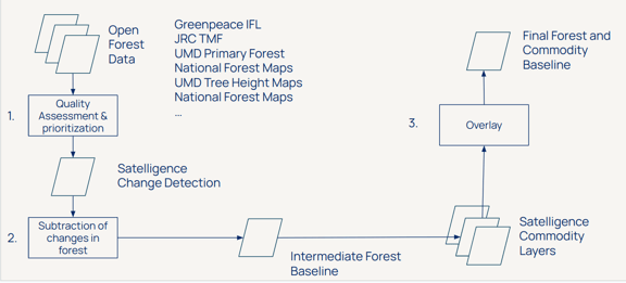
The workflow of creating the Satelligence Forest Baseline
Change Detection AlgorithmsSatelligence uses 2 change detection algorithms. One for optical data such as Landsat and Sentinel-2, and another for radar data such as Sentinel-1.
The optical change detection algorithm is called SpatioTemporalAdaptiveBareness (STAB). In short, it uses forest statistics of the entire landscapes and compares these statistics to a pixel of interest. If this pixel has much higher Bareness (level of bare soil) than all of the surrounding forest, the pixel is flagged as deforested. The advantage of using an algorithm which uses an adaptive threshold is that it can take seasonality into account, which is the case for many dry tropical forests and savanna such as the Cerrado and Chaco areas in South America.
The radar change detection algorithm is called ‘Bayesian Iterative Updating’. This is a statistical method, where current observations are compared to historical observations to determine the probability of change. For more in-depth information about the Bayesian Iterative Updating Method, read further here.
Satelligence uses a minimum mapping unit for detecting change across forest and vegetation classes respectively of 0.1ha. This threshold of 0.1 ha is set as this is the minimum surface area that can reliably be classified as deforestation detected. It is sufficient to capture both forest degradation and deforestation.
In areas with lower risk for deforestation, Satelligence uses open data to detect change. Also for these areas, change is only flagged as deforestation or conversion where it overlaps with the Nature & Commodity Baseline. Several open datasets are harmonized together to provide the broadest coverage in space and time, as well across forest and other natural classes. Currently GWF Tree Cover Loss (GFW-TCL) and GFW Integrated Deforestation Alerts (GFW-IDA, already the combination of GLAD-L, GLAD-S2 and RADD) are used and provide long term coverage (GFW-TCL) as well as timely temporal resolution within plus and minus 30 degrees latitude (GFW-IDA) for forest classes. Dist-Alert is being integrated to further expand coverage of natural classes other than forest.
While our methodology for detecting change varies slightly depending on regional data sources (such as direct satellite processing in tropical regions versus preprocessed open data streams in temperate and boreal regions), we are standardizing our 0.1 ha MMU filter globally. This update will ensure complete consistency across all regions and will be fully live by the end of Q12027.