
Discrepancies can arise from differences in forest baselines, satellite datasets, detection methods, mapping units or classification thresholds. For example, one system may flag forest loss within a palm plantation, while another flags this same event as routine replanting on established agricultural land. Similarly, distinguishing forest from agroforestry from agricultural trees in shade grown coffee or cocoa systems can be challenging.
This is where methodological transparency becomes critical. A summary "deforestation-free" conclusion from another provider is not, by itself, sufficient to dismiss an identified concern. Operators need to understand the evidence and reasoning behind the different assessments.
Recommended practice
Where conflicting results arise, we recommend that operators:
- Understand the discrepancy: Request the alternative provider's methodology and supporting information, including forest baselines, datasets, assumptions, thresholds and assessment period.
- Investigate the specific detection: Review the original alert alongside the alternative assessment, land-use history and available supplier evidence. Where necessary and feasible, seek additional verification with Very High Resolution imagery or field verification.
- Engage suppliers proportionately: Request clarification and supporting evidence, recognising that field verification may not always be practical, particularly for smallholders. Meaningful engagement should be prioritised over automatically excluding suppliers.
- Document the decision: Record the original detection, conflicting evidence, supplier engagement, additional checks and the rationale for the final decision in the Satelligence Case Tracker.
The objective is not necessarily for every system to agree, but to establish a transparent, explainable and auditable basis for the due diligence decision.
Other steps to consider
Examine high resolution Planet satellite imagery on the Satelligence platform to verify if you can visually observe the deforestation on the map. If you can, this shows that the Satelligence monitoring model has correctly identified the deforestation.
Investigate accuracy of plot data. Plot data quality (points or polygons) varies wildly and mistakes do happen. Indicators of data collection mistakes are, for example: a plot is very large and likely includes more than the production area for one plot, a plot is further removed from the mill or cooperative than others are, or patterns within the plot data that indicate that data was projected wrongly. It remains the company’s responsibility to do its due diligence on its supply chain and thus ensure the correctness of the traceability and plot data. Hence, a correction of a polygon by a supplier should only be accepted when the initial polygon was incorrect.
Investigate changes in this plot since the cut-off date. Is this an old plantation which has recently been cleared for replanting? Is it an agroforestry plantation? Pictures and planting logs can help in determining whether the plot has been in agricultural use since before the cut-off date.
Collect photographic evidence of the situation on ground. With Satelligence, you can check the validity of such evidence through the deforestation timeline in the platform and the Very High Resolution Planet satellite imagery.
Managing Evidence
In some cases, a supplier may respond that the plot in question is deforestation free according to a different source of forest status, such as a national land use map or open source data.
Ask your Supplier to submit and record their evidence using the ‘Case Tracker’ for further investigation. Evidence should include:
- A screenshot or screen recording of the plot with the forest baseline that was used to make the assessment;
- Plot ID or location coordinates;
- A short description of the contested deforestation assessment (for example, is it a false positive or false negative?)
A false positive is when an area is incorrectly marked as deforested. For example, when an old plantation is cut down and replanted, or a coffee growing area is pruned.
A false negative is when an area is deforested, but it was not flagged as such.
Review the evidence submitted by your supplier and make an assessment if the deforestation detections are indeed correct, or whether there is an error in the Satelligence Harmonized Nature and Commodity Baseline (H-NCB) which needs to be corrected.
If the evidence submitted by your supplier is deemed sufficient, in accordance with your own due diligence policies, then the Case related to the plot in question can be changed from 'Investigating' to Dismissed'. This NDF plot will then no longer affect your overall Deforestation Free score.
Note that the Satelligence Harmonized Nature and Commodity Baseline (H-NCB) is in most occurrences a much more precise model of forest status than static land use maps. Our H-NCB uses open data sources and national land use maps, combines them with commodity layers and applies a coherent and consistent understanding of forest classes through time. Static land use maps are updated irregularly and tend to have limited correction for commodity layers. Open data tends to flag any tree loss and hence often overestimates deforestation. Nevertheless, in a few cases, such as older plantations and extensive agroforestry systems, the Satelligence model may generate a false positive or negative, in which case we welcome your prompt feedback.
Real world example
A Satelligence coffee client asked their Supplier to submit plots to the Satelligence platform to assess their deforestation status.
One of the plots (in Brazil) was marked Non-Deforestation Free.
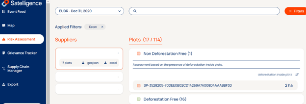
Snapshot of the Risk Assessment outcome in the Satelligence platform
The client shared this outcome with the Supplier and requested them to cross validate the result with their own due diligence system.
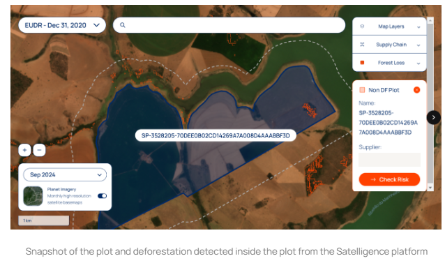
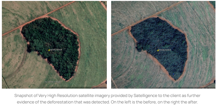
Satelligence detected 2ha of deforestation on the periphery of the forest located inside the plot, as shown in the image above.
The Supplier replied that they did not detect any deforestation inside the plot, and assessed this plot for deforestation using the BRAIN/CECAFE platform in Brazil utilizing PRODES and MAPBIOMAS datasets. The supplier explained that the PRODES protocol is part of the Satellite Deforestation Monitoring Project by Brazil's National Institute for Space Research (INPE). This program monitors and quantifies deforestation across Brazilian biomes. Using high-resolution satellite imagery, the programme conducts annual analyses to identify deforested areas, defining deforestation as “the complete removal of forest cover in areas larger than 6.25 hectares”.
The Supplier shared high-resolution historical satellite images of the area (see below), and explained that you can see coffee plants growing and being pruned throughout the year, but with this exact part remaining untouched.
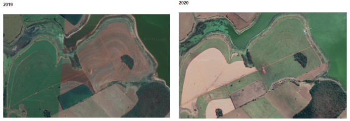
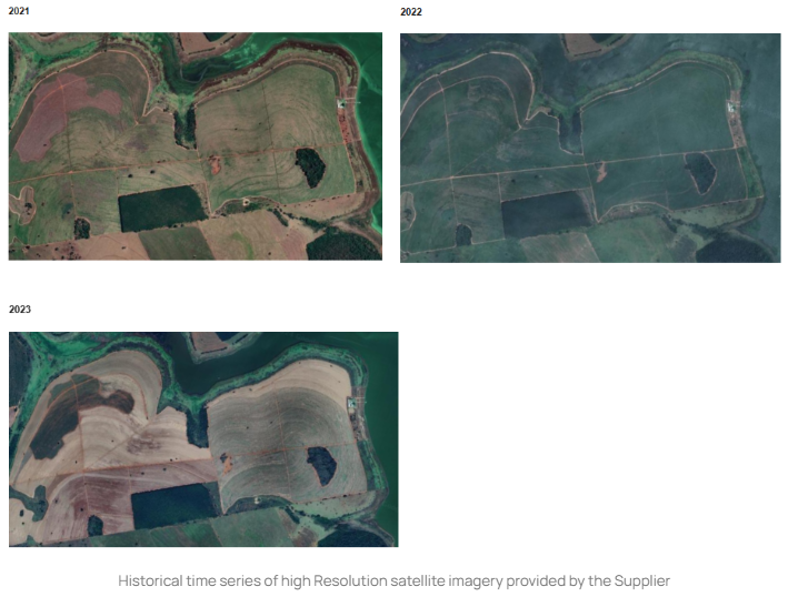
Satelligence investigated the evidence provided by the supplier. But the conclusion of the deforestation risk assessment remained unchanged: this case was not an example of falsely detected deforestation. Although marginal and on the edge of the ‘green patch’, the deforestation was correctly detected inside the plot and therefore flagged as Non Deforestation Free. The Supplier’s deforestation monitoring system did not detect this 2ha deforestation as their system defines deforestation differently from Satelligence EUDR:
- They detect only complete removal of forest cover in areas larger than 6.25ha.
- Satelligence detects removal and disturbance of forest in areas larger than 0.5ha.
The Client decides whether the Supplier has provided sufficient evidence to demonstrate that this plot can be considered negligible risk.
The Client can store this information as evidence in the Case Tracker, to demonstrate their due diligence to the Competent Authorities or an auditor: they investigated the supplier and their respective Non DF plots., and resolved the case based on the provided documentation to permit sourcing for the EU market.
The challenge with EUDR is that on the one hand you can argue, this is not relevant because it is a very small patch of deforestation that has not been converted into agricultural use (yet). Thus under EUDR it is not considered deforestation. On the other hand, you can argue that this deforestation happened inside the plot and is therefore noncompliant. Unless the Supplier is turning this into a road/urban or any land use the EUDR explicitly excludes. This is where our updated commodity maps, released throughout 2025 and 2026, will play a crucial role in identifying deforestation that is relevant to your supply chain.