Tree cover changes are mapped using an algorithm called ‘Iterative Bayesian Updating’; a method that was first applied to radar satellite images for deforestation detection by Wageningen University in collaboration with Satelligence.
This method calculates the probability that an area is deforested and temporally “stacks” these probabilities to have a higher degree of certainty about the deforestation event. The method first ‘flags’ pixels as possibly deforested, which can be confirmed or rejected by later measurements.
For our application this means that up until the area changes (i.e. the event), we have a period where we know that an area is forest and we know its characteristics as seen by the satellite (i.e. the prior knowledge of conditions related to the event, Figure 1).
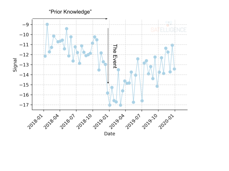
Figure 1. Radar Satellite signal through time. Showing the ‘prior knowledge’ (when the area was forest) and ‘the event’ (deforestation) parts which are used in Bayesian statistics
If we want to assess changes starting 1 October 2018, we can take the previous year as our prior knowledge condition. If we combine all the signals for an entire year for a single pixel, we can calculate the mean and the standard deviation. From that we can create a normal (‘Gaussian”) distribution for the signals that the satellite receives when it looks at forest. At the same time, we also know that in the event of deforestation, the signal the satellite receives reduces. With this information we can construct another distribution for the same area, but now with a lower mean.
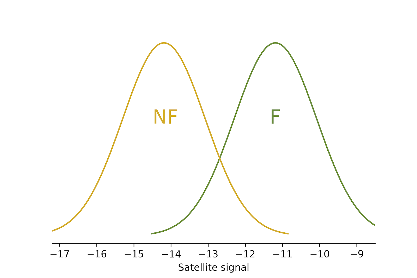
Figure 2. Radar signals distributions for non-forest (NF) and non-forest (F)
Now we know what the distributions of the signal from the satellite look like for forest and non-forest. When a new satellite image comes in, we calculate the probability that the new measurement fits within the Forest class and the Non-Forest class, and consequently, the probability that an area has changed.
When the probability of deforestation reaches a certain threshold (50%), the pixel is ‘flagged’. Being flagged in this case means that we think there has been change, but we are not completely sure yet, so we wait for more satellite measurements to confirm the change. We confirm the change when the algorithm is 98% certain.
Radar data is noisy, which is why we need the iterative updating part of the algorithm. A single ‘low’ observation from a radar satellite could indicate deforestation, but it might also be noise. To make sure that we do not classify noise as deforestation, we keep track of the probability that something has been deforested, meaning, we update the probability in an iterative way. This iterative updating starts only after a pixel has been flagged as possibly being deforested.
A similar process happens spatially. A single flagged pixel could indicate deforestation, but chances of it being noise become smaller when neighboring pixels are also flagged as deforestation. The clustered and flagged pixels are stored as deforestation patches. This way we guarantee our global consistent high accuracy.
Imagery from Landsat and Sentinel-2 optical satellites and the Sentinel-1 radar satellites is used as input. Using multiple input sources, revisit time is reduced to 2-3 days. Additionally, radar imagery can detect tree cover changes through cloud cover.
Using this combination of satellite imagery inputs, the change detection accuracy reached is higher than 90% globally, and higher than 95% in the humid tropics (see Appendix III).
References
-
Reiche, J., Verhoeven, R., Verbesselt, J., Hamunyela, E., Wielaard, N. & Herold, M. 2018. Characterizing Tropical Forest Cover Loss Using Dense Sentinel-1 Data and Active Fire Alerts. In: Remote Sensing. 10, 5, 18 p., 777.
-
Mullissa, A. G., Marcos, D., Tuia, D., Herold, M. & Reiche, J. 2022. deSpeckNet: Generalizing Deep Learning-Based SAR Image Despeckling. In: IEEE Transactions on Geoscience and Remote Sensing. 60, p. 1-15
-
Reiche, J., Mullissa, A., Slagter, B., Gou, Y., Tsendbazar, N-E., Odongo-Braun, C., Vollrath, A., Weisse, M. J., Stolle, F., Pickens, A., Donchyts, G., Clinton, N., Gorelick, N. & Herold, M. 2021. Forest disturbance alerts for the Congo Basin using Sentinel-1. In: Environmental Research Letters. 16, 2, 024005.
-
Balling, J., Herold, M. & Reiche, J. 2023. How textural features can improve SAR-based tropical forest disturbance mapping. In: International Journal of applied Earth Observation and Geoinformation. 124, 103492.