Deforestation detection consists of two basic components: knowing where the forest is located, and knowing if and when it changed to a non-forest state, i.e. deforestation.
We locate forest areas using our own Satelligence Forest Baseline, and for knowing when forest changes into another state we use change detection algorithms. This system is faster and more precise than popular public alternatives without the need for expensive commercial input data.
Forest Baseline
Satelligence uses a hybrid approach for forest baseline creation. Meaning that we use both open data such as the Tropical Moist Forest Layers from JRC, as well as our own proprietary data.
Open data layers are curated, quality controlled and the class types are harmonized to match our final classification scheme. A prioritization on the basis of quality for deforestation monitoring related to soft commodities determines how the layers are combined
To ensure the Forest and Commodity Baseline has the proper cutoff date (ie 2020-12-31), all forest in the open layers that has been deforested before that date is removed from the layers.
As a last step we add-in our own proprietary soft commodity (EUDR commodities and others such as sugarcane, maize etc.) layers, which are created using Landsat, Sentinel-1 and Sentinel-2 data. This step ensures further removal of false positives in the forest layers, which in many areas are still present.
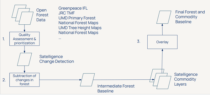
The workflow of creating the Satelligence Forest Baseline