In this section we explain why expensive very-high resolution (VHR) data is unnecessary for monitoring your supply chain, and why the Satelligence detection system only uses open source satellite data. It basically comes down to:
- Open source satellite data is detailed enough to detect deforestation
- Very High Resolution satellite data is very expensive (~10 USD per km2)
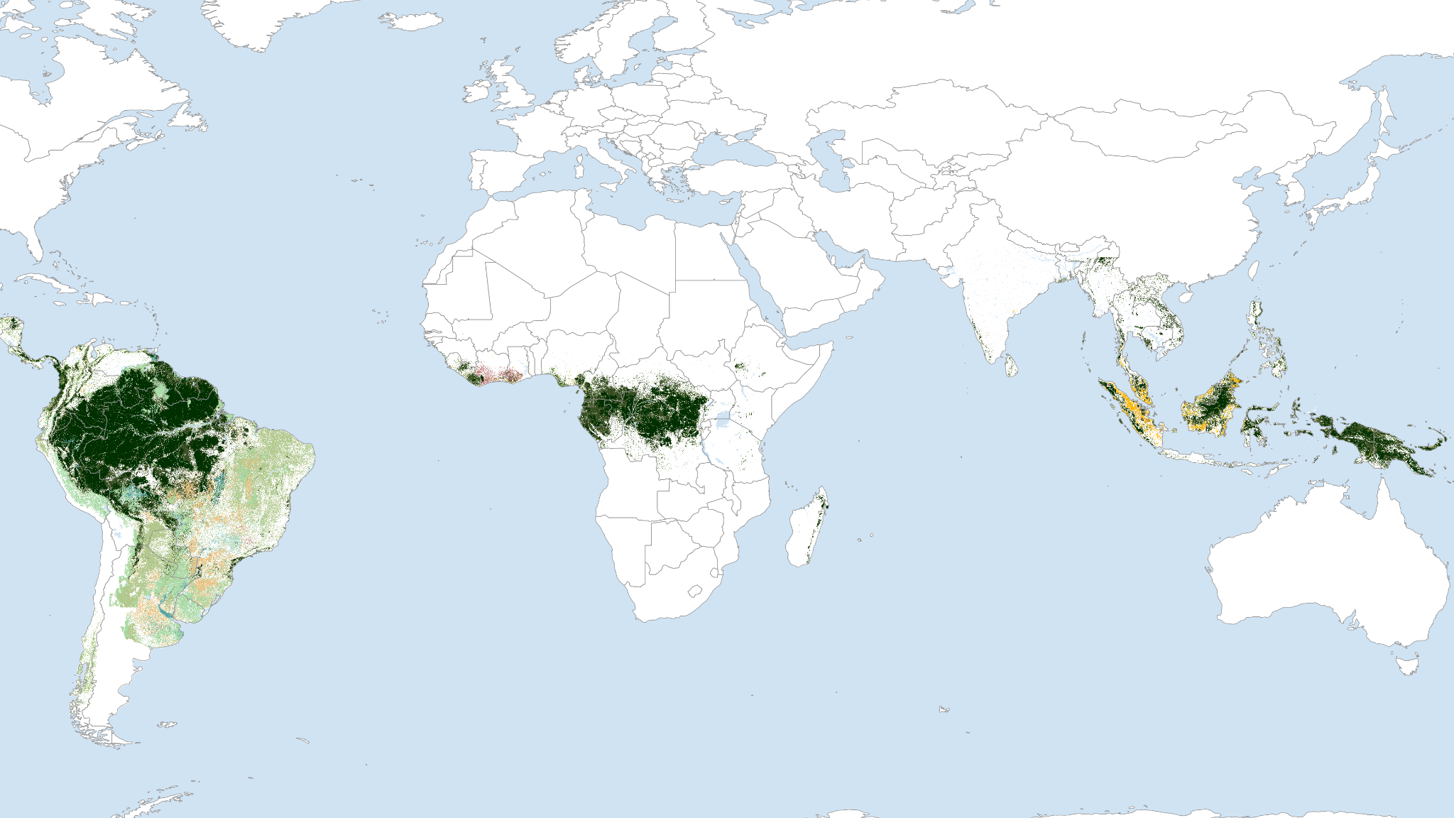
Map showing the full area for which the Satelligence system provides operational insights on a daily basis
How to get reliable deforestation alerts
Using freely available data may sound like a cheap alternative. But if you want to monitor your supply chain for zero deforestation, it is the reliability of your deforestation alerts that is most important. To make sure you get the best results, we continuously check our algorithms for timeliness, spatial resolution, and accuracy.
The table below compares our algorithms to other available systems.
|
Name |
Spatial Coverage |
Spatial Resolution |
Revisit time |
Satellite Data |
Uses Radar to look through clouds |
|
Satelligence |
Global Tropics |
10m |
Daily |
Open |
Yes |
|
GLAD |
Global Tropics |
30m |
Weekly |
Open |
No |
|
TerraBrasilis PRODES |
Brazil |
16m |
Monthly |
Open |
No |
Overview of some well-known deforestation detection systems.
We cannot compare our system to other providers that use high to very-high resolution (VHR) data for deforestation detection. This is because their products and services are commercially protected and therefore unavailable for testing. What we can do, however, is to make the case why you do not need them in order to have access to reliable and usable deforestation alerts.
For the areas we work in, a daily revisit time [of optical imagery] does not help if your entire area is (almost) always covered by clouds.
Checking temporal resolution of commercial data
We sometimes get the question why we do not use Planet Imagery for our services, because then you would have access to daily imagery. Planet is a fantastic source for imagery for many applications, for e.g. baseline data and agricultural applications. Also for change detection a daily revisit time is great. But for the areas we work in, a daily revisit time does not help if your area of interest is (almost) always covered by clouds. That is why radar data is necessary.
In the animation below you can see an area we mapped in Ghana using monthly “cloud-free” composites from Planet, for the period January 2018 to October 2019. You can see that for many months of the year, the area is covered by clouds.

Monthly imagery from Planet of test area in Ghana (Jan 2018 - Oct 2019), demonstrating the challenge of persistent cloud cover.
Incorporating Planet imagery into our service, would only result in a minor increase in accuracy and timeliness, but significantly increase the cost of the service. Using the combination of the Sentinel-1, Sentinel-2 and Landsat constellations, we can get up to almost-daily updates of many places in the tropics anyway!
Spatial resolution of commercial data
High to very-high resolution (VHR) deforestation products are available in the market. These can range from lower than 10m down to 50cm for satellite services. The idea is that, using these services you can get more accurate deforestation products. Although intuitively this might seem true, we find it is a typical case of searching for an elephant with a microscope. We believe you need the right tool for your problem, and 10m pixel size is more than enough for almost all applications.
Below you see an example of the Satelligence change detection at work in a small area in Sumatra, Indonesia. The deforested patch is about ~0.15 ha and the algorithm picks up the tree cover loss very nicely. Our work on quality control shows that we can accurately detect tree cover loss as small as 0.05ha.
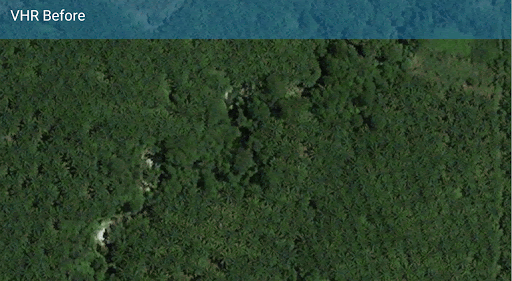
VHR imagery of an area on Sumatra, Indonesia. Showing a tree cover clearing of approximately 0.15 ha. The Satelligence algorithm very clearly detects this tree cover loss.
The question, however, is: do you really need this kind of detail everywhere?
Seeing every tree fall leads to information overload. Most importantly, at this level of detail you are actually monitoring forest degradation. The definition of deforestation in many countries refers to areas of tree cover loss larger than 0.5 or 1 hectare. This means that Sentinel-type data is more than sufficient for highly detailed, fast and accurate detection, and commercial very-high resolution data is not needed for a global supply chain monitoring service.
Additionally, using commercial very-high resolution data comes at a price. A very steep price. The prices range from around 5 USD for 1.5m imagery to almost 30 USD for 50cm imagery for a single km2. These are all higher than what we charge for a complete service package!